
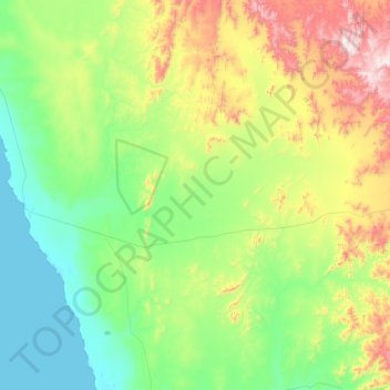
Richtersveld Ward 3 topographic map
Interactive map
Click on the map to display elevation.
About this map
Name: Richtersveld Ward 3 topographic map, elevation, terrain.
Average elevation: 948 ft
Minimum elevation: 0 ft
Maximum elevation: 3,550 ft
Other topographic maps
Click on a map to view its topography, its elevation and its terrain.
Port Nolloth
South Africa > Northern Cape > Namakwa District Municipality > Richtersveld Local Municipality
Port Nolloth, Richtersveld Local Municipality, Namakwa District Municipality, Northern Cape, South Africa
Average elevation: 39 ft
Alexander Bay
South Africa > Northern Cape > Namakwa District Municipality > Richtersveld Local Municipality
Alexander Bay, Richtersveld Local Municipality, Namakwa District Municipality, Northern Cape, South Africa
Average elevation: 49 ft