Geolocate

Trabzon topographic map

Click on the map to display elevation.

About this map

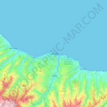
Name: Trabzon topographic map, elevation, terrain.

Location: Trabzon, Ortahisar, Trabzon, Black Sea Region, 61050, Turkey (40.84546 39.57015 41.16546 39.89015)

Average elevation: 791 ft

Minimum elevation: 0 ft

Maximum elevation: 6,112 ft

Other topographic maps

Click on a map to view its topography, its elevation and its terrain.

Fatih Parkı

Turkey > Ortahisar

Average elevation: 197 ft

Gülbaharhatun Mahallesi

Turkey > Ortahisar

Average elevation: 213 ft

Hızırbey Mahallesi

Turkey > Ortahisar

Average elevation: 92 ft

Gear up for your next adventure:

🚗GPS Dash Cams - Record your scenic drives through mountain passes and canyons
🧭Orienteering Set - Complete compass and map reading kit
📶Vehicle Signal Boosters - Improve reception in rural areas while driving to trailheads
🥄Camping Utensil Set - Lightweight utensils for outdoor meals
🦶Carbon Trekking Poles - Reduce knee impact on steep descents with ultra-light poles

As an Amazon Associate, this site earns from qualifying purchases at no extra cost to you.