
Departamento Formosa topographic map
Interactive map
Click on the map to display elevation.
About this map
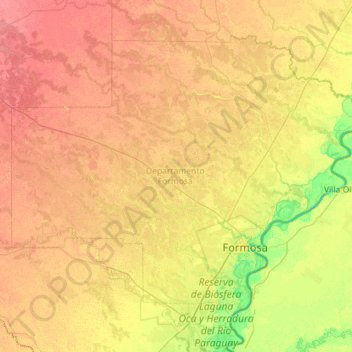
Name: Departamento Formosa topographic map, elevation, terrain.
Location: Departamento Formosa, FSA, Argentinien (-26.38507 -58.92944 -25.56883 -57.79309)
Average elevation: 223 ft
Minimum elevation: 154 ft
Maximum elevation: 282 ft
Other topographic maps
Click on a map to view its topography, its elevation and its terrain.
Río Bermejo
Río Bermejo, Municipio de El Sauzalito, Departamento Bermejo, FSA, H3526, Argentinien
Average elevation: 705 ft