
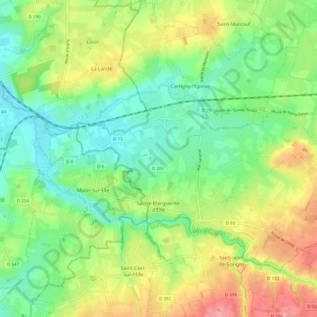
Sainte-Marguerite-d'Elle topographic map
Interactive map
Click on the map to display elevation.
About this map
Name: Sainte-Marguerite-d'Elle topographic map, elevation, terrain.
Average elevation: 125 ft
Minimum elevation: 0 ft
Maximum elevation: 325 ft
Other topographic maps
Click on a map to view its topography, its elevation and its terrain.
Estry
France > Normandy > Calvados > Valdallière
Estry, Valdallière, Vire, Calvados, Normandy, Metropolitan France, 14410, France
Average elevation: 636 ft
Mont Pinçon
France > Normandy > Calvados > Les Monts d'Aunay
Mont Pinçon, Les Monts d'Aunay, Vire, Calvados, Normandy, Metropolitan France, 14770, France
Average elevation: 932 ft
Saint-Sylvain
Saint-Sylvain, Caen, Calvados, Normandy, Metropolitan France, 14190, France
Average elevation: 213 ft
Huppain
France > Normandy > Calvados > Port-en-Bessin-Huppain
Huppain, Port-en-Bessin-Huppain, Bayeux, Calvados, Normandy, Metropolitan France, 14520, France
Average elevation: 148 ft
Livarot
France > Normandy > Calvados > Livarot-Pays-d'Auge
Livarot, Livarot-Pays-d'Auge, Lisieux, Calvados, Normandy, Metropolitan France, 14140, France
Average elevation: 420 ft
Grandcamp-Maisy
Grandcamp-Maisy, Bayeux, Calvados, Normandy, Metropolitan France, 14450, France
Average elevation: 59 ft
Luc-sur-Mer
Luc-sur-Mer, Caen, Calvados, Normandy, Metropolitan France, 14530, France
Average elevation: 49 ft
Cricqueville-en-Bessin
Cricqueville-en-Bessin, Bayeux, Calvados, Normandy, Metropolitan France, 14450, France
Average elevation: 49 ft
Hérouville-Saint-Clair
Hérouville-Saint-Clair, Caen, Calvados, Normandy, Metropolitan France, 14200, France
Average elevation: 112 ft
Arromanches-les-Bains
Arromanches-les-Bains, Bayeux, Calvados, Normandy, Metropolitan France, 14117, France
Average elevation: 98 ft
Port-en-Bessin-Huppain
Port-en-Bessin-Huppain, Bayeux, Calvados, Normandy, Metropolitan France, 14520, France
Average elevation: 95 ft
Ver-sur-Mer
Ver-sur-Mer, Bayeux, Calvados, Normandy, Metropolitan France, 14114, France
Average elevation: 92 ft
Manoir de la Rivière
France > Normandy > Calvados > Sainte-Marguerite-d'Elle
Manoir de la Rivière, D 145, La forge, Sainte-Marguerite-d'Elle, Bayeux, Calvados, Normandy, Metropolitan France, 14330, France
Average elevation: 223 ft
Fontenay-le-Pesnel
France > Normandy > Calvados > Fontenay-le-Pesnel
Fontenay-le-Pesnel, Bayeux, Calvados, Normandy, Metropolitan France, 14250, France
Average elevation: 305 ft
Le Castelet
France > Normandy > Calvados > Le Castelet
Le Castelet, Caen, Calvados, Normandy, Metropolitan France, 14540, France
Average elevation: 295 ft
Saint-Martin-de-Fontenay
France > Normandy > Calvados > Saint-Martin-de-Fontenay > Saint-Martin-de-Fontenay
Saint-Martin-de-Fontenay, Caen, Calvados, Normandy, Metropolitan France, 14320, France
Average elevation: 157 ft
Pont-d'Ouilly
France > Normandy > Calvados > Pont-d'Ouilly
Pont-d'Ouilly, Caen, Calvados, Normandy, Metropolitan France, 14690, France
Average elevation: 535 ft
Esquay-Notre-Dame
France > Normandy > Calvados > Esquay-Notre-Dame
Esquay-Notre-Dame, Caen, Calvados, Normandy, Metropolitan France, 14210, France
Average elevation: 282 ft
Les Manoirs
France > Normandy > Calvados > Glanville > Les Manoirs
Les Manoirs, Glanville, Lisieux, Calvados, Normandy, Metropolitan France, 14950, France
Average elevation: 315 ft
La Villette
France > Normandy > Calvados > La Villette
La Villette, Vire, Calvados, Normandy, Metropolitan France, 14570, France
Average elevation: 673 ft
Trouville-sur-Mer
Trouville-sur-Mer, Lisieux, Calvados, Normandy, Metropolitan France, 14360, France
Average elevation: 89 ft
Mondeville
Mondeville, Caen, Calvados, Normandy, Metropolitan France, 14120, France
Average elevation: 72 ft
Saint-Gabriel-Brécy
France > Normandy > Calvados > Creully sur Seulles
Saint-Gabriel-Brécy, Creully sur Seulles, Bayeux, Calvados, Normandy, Metropolitan France, 14480, France
Average elevation: 131 ft
Vire
France > Normandy > Calvados > Vire Normandie
Vire, Vire Normandie, Vire, Calvados, Normandy, Metropolitan France, 14500, France
Average elevation: 512 ft