
Salem Woods topographic map
Interactive map
Click on the map to display elevation.
About this map
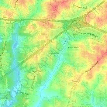
Name: Salem Woods topographic map, elevation, terrain.
Average elevation: 791 ft
Minimum elevation: 699 ft
Maximum elevation: 879 ft
Other topographic maps
Click on a map to view its topography, its elevation and its terrain.
West Highlands
United States > North Carolina > Forsyth County > Winston-Salem
Average elevation: 883 ft
Briarcliff Manor
United States > North Carolina > Forsyth County > Winston-Salem
Average elevation: 814 ft
Mallard Lakes
United States > North Carolina > Forsyth County > Winston-Salem
Average elevation: 876 ft
Stanleyville
United States > North Carolina > Forsyth County > Winston-Salem
Average elevation: 889 ft
Pebble Creek Estates
United States > North Carolina > Forsyth County > Winston-Salem
Average elevation: 922 ft
Salem Lake
United States > North Carolina > Forsyth County > Winston-Salem > Woodbridge
Average elevation: 866 ft
Reynolda Village
United States > North Carolina > Forsyth County > Winston-Salem
Average elevation: 912 ft
Bethania Station
United States > North Carolina > Forsyth County > Winston-Salem
Average elevation: 853 ft
Salem Creek
United States > North Carolina > Forsyth County > Winston-Salem > Salem
Average elevation: 823 ft
Beeson Crossroads
United States > North Carolina > Forsyth County > Winston-Salem > Beeson Crossroads
Average elevation: 932 ft