
Kaźmierz topographic map
Interactive map
Click on the map to display elevation.
About this map
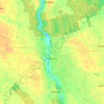
Name: Kaźmierz topographic map, elevation, terrain.
Average elevation: 289 ft
Minimum elevation: 230 ft
Maximum elevation: 322 ft
Other topographic maps
Click on a map to view its topography, its elevation and its terrain.
Mokrz
Poland > Greater Poland Voivodeship > Szamotuły County > Mokrz
Mokrz, gmina Wronki, Szamotuły County, Greater Poland Voivodeship, 64-510, Poland
Average elevation: 213 ft
Konin
Poland > Greater Poland Voivodeship > Szamotuły County
Konin, gmina Pniewy, Szamotuły County, Greater Poland Voivodeship, 62-045, Poland
Average elevation: 328 ft