
Make a donation
Gear up for your next adventure:
As an Amazon Associate, this site earns from qualifying purchases at no extra cost to you.
Hemsbach topographic map
Click on the map to display elevation.
Make a donation
Gear up for your next adventure:
As an Amazon Associate, this site earns from qualifying purchases at no extra cost to you.
About this map
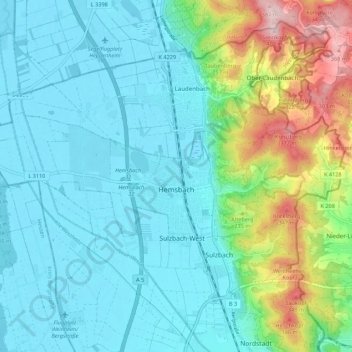
Name: Hemsbach topographic map, elevation, terrain.
Average elevation: 528 ft
Minimum elevation: 308 ft
Maximum elevation: 1,309 ft
Make a donation
Gear up for your next adventure:
As an Amazon Associate, this site earns from qualifying purchases at no extra cost to you.
Other topographic maps
Click on a map to view its topography, its elevation and its terrain.
Sinsheim-Steinsfurt / Insenbach
Germany > Baden-Württemberg > Rhein-Neckar-Kreis > Sinsheim
Average elevation: 669 ft
Gauangelloch
Germany > Baden-Württemberg > Rhein-Neckar-Kreis > Leimen > Gauangelloch
Average elevation: 725 ft
Neckar-Wimmersbach
Germany > Baden-Württemberg > Rhein-Neckar-Kreis > Eberbach
Average elevation: 840 ft