Geolocate

Bluff topographic map

Click on the map to display elevation.

About this map

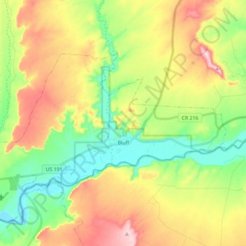
Name: Bluff topographic map, elevation, terrain.

Location: Bluff, San Juan County, Utah, 84512, United States (37.25709 -109.64793 37.33135 -109.48441)

Average elevation: 4,672 ft

Minimum elevation: 4,275 ft

Maximum elevation: 5,236 ft

San Juan County trails, hiking, mountain biking, running and outdoor activities

Other topographic maps

Click on a map to view its topography, its elevation and its terrain.

Colorado Plateau

United States > Utah > San Juan County

Younger igneous rocks form spectacular topographic features. The Henry Mountains, La Sal Range, and Abajo Mountains, ranges that dominate many views in southeastern Utah, are formed about igneous rocks that were intruded in the interval from 20 to 31 million years: some igneous intrusions in these mountains…

Average elevation: 4,961 ft

Abajo Mountains

United States > Utah > San Juan County

Average elevation: 8,481 ft

Cream Pots

United States > Utah > San Juan County

Average elevation: 6,660 ft

Rustler Canyon

United States > Utah > San Juan County

Average elevation: 4,455 ft

Long Canyon

United States > Utah > San Juan County

Average elevation: 5,505 ft

Sentinel Mesa

United States > Utah > San Juan County

Monument Valley is part of the Colorado Plateau. The elevation of the valley floor ranges from 5,000 to 6,000 feet (1,500 to 1,800 m) above sea level. The floor is largely siltstone of the Cutler Group, or sand derived from it, deposited by the meandering rivers that carved the valley. The valley's vivid red…

Average elevation: 5,522 ft

Colorado Plateau

United States > Utah > San Juan County

Younger igneous rocks form spectacular topographic features. The Henry Mountains, La Sal Range, and Abajo Mountains, ranges that dominate many views in southeastern Utah, are formed about igneous rocks that were intruded in the interval from 20 to 31 million years: some igneous intrusions in these mountains…

Average elevation: 4,961 ft

Red Canyon

United States > Utah > San Juan County

Average elevation: 4,806 ft

Rustler Canyon

United States > Utah > San Juan County

Average elevation: 4,455 ft

Harmony Flat

United States > Utah > San Juan County

Average elevation: 6,640 ft

Upheaval Dome

United States > Utah > San Juan County

Average elevation: 5,338 ft

Big Canyon

United States > Utah > San Juan County > Blanding

Average elevation: 6,155 ft

Colorado Plateau

United States > Utah > San Juan County

Younger igneous rocks form spectacular topographic features. The Henry Mountains, La Sal Range, and Abajo Mountains, ranges that dominate many views in southeastern Utah, are formed about igneous rocks that were intruded in the interval from 20 to 31 million years: some igneous intrusions in these mountains…

Average elevation: 4,961 ft

Gear up for your next adventure:

🧭Map Reading Tools - Tools and kits for map navigation
🪵Folding Camp Saw - Compact saw for wood and campsite work
💧Water Purification System - Clean water on the trail with reliable purifiers
🛏️Cold Weather Sleeping Bag - Warm sleeping bag for cold conditions
🔥Plasma Lighters - Windproof lighters that work in any weather condition

As an Amazon Associate, this site earns from qualifying purchases at no extra cost to you.