
Make a donation
Gear up for your next adventure:
As an Amazon Associate, this site earns from qualifying purchases at no extra cost to you.
Tully topographic map
Click on the map to display elevation.
Make a donation
Gear up for your next adventure:
As an Amazon Associate, this site earns from qualifying purchases at no extra cost to you.
About this map
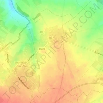
Name: Tully topographic map, elevation, terrain.
Average elevation: 318 ft
Minimum elevation: 207 ft
Maximum elevation: 381 ft
Make a donation
Gear up for your next adventure:
As an Amazon Associate, this site earns from qualifying purchases at no extra cost to you.
Other topographic maps
Click on a map to view its topography, its elevation and its terrain.
La Boisselle
France > Hauts-de-France > Somme > Ovillers-la-Boisselle > La Boisselle
Average elevation: 358 ft
Make a donation
Gear up for your next adventure:
As an Amazon Associate, this site earns from qualifying purchases at no extra cost to you.
Beaumont-Hamel Newfoundland Memorial Park
France > Hauts-de-France > Somme > Beaumont-Hamel
Average elevation: 417 ft