
Ha'il topographic map
Interactive map
Click on the map to display elevation.
About this map
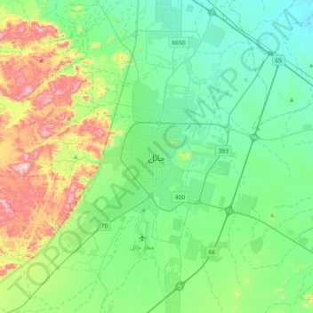
Name: Ha'il topographic map, elevation, terrain.
Location: Ha'il, Hail, Ḥa'il Province, 55421, Saudi Arabia (27.36087 41.53860 27.68087 41.85860)
Average elevation: 3,445 ft
Minimum elevation: 2,913 ft
Maximum elevation: 5,030 ft
Other topographic maps
Click on a map to view its topography, its elevation and its terrain.
Baqa
Baqa, Ḥa'il Province, 81911, Saudi Arabia
Average elevation: 2,280 ft
الخوير
الخوير, Baqa, Ḥa'il Province, Saudi Arabia
Average elevation: 2,310 ft
Ash Shinan
Ash Shinan, Ḥa'il Province, Saudi Arabia
Average elevation: 2,851 ft
Jabal Sayid
Jabal Sayid, Hail, Ḥa'il Province, Saudi Arabia
Average elevation: 3,885 ft
At Turbiyah
Saudi Arabia > Ḥa'il Province > At Turbiyah
At Turbiyah, Hail, Ḥa'il Province, Saudi Arabia
Average elevation: 2,818 ft