
Thank you for supporting this site ❤️
Make a donation
Make a donation
Gear up for your next adventure:
As an Amazon Associate, this site earns from qualifying purchases at no extra cost to you.
Becerril de la Sierra topographic map
Click on the map to display elevation.
Thank you for supporting this site ❤️
Make a donation
Make a donation
Gear up for your next adventure:
As an Amazon Associate, this site earns from qualifying purchases at no extra cost to you.
About this map
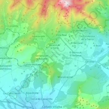
Name: Becerril de la Sierra topographic map, elevation, terrain.
Location: Becerril de la Sierra, Community of Madrid, 28490, Spain (40.64564 -4.00457 40.76714 -3.83015)
Average elevation: 3,760 ft
Minimum elevation: 2,871 ft
Maximum elevation: 7,251 ft
Thank you for supporting this site ❤️
Make a donation
Make a donation
Gear up for your next adventure:
As an Amazon Associate, this site earns from qualifying purchases at no extra cost to you.
Other topographic maps
Click on a map to view its topography, its elevation and its terrain.
Madrid
Spain > Community of Madrid > Área metropolitana de Madrid y Corredor del Henares > Madrid
Average elevation: 2,133 ft