Geolocate

Caratinga topographic map

Click on the map to display elevation.

Caratinga

Caratinga is a municipality in eastern Minas Gerais state, Brazil. The population in 2020 was 92,603 inhabitants and the total area of the municipality was 1,251 km2. The elevation is 578 meters above sea level, with maximum elevation of 1,516 m in the Serra do Rio Preto and 330 m at the mouth of the Córrego Boachá.

Wikipedia (CC-BY-SA 3.0)

About this map

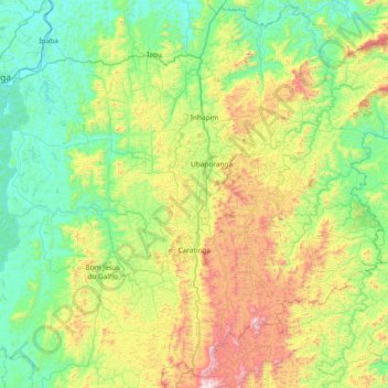
Name: Caratinga topographic map, elevation, terrain.

Location: Caratinga, Região Geográfica Imediata de Caratinga, Região Geográfica Intermediária de Ipatinga, Minas Gerais, Southeast Region, Brazil (-19.93953 -42.52227 -19.43964 -41.77800)

Average elevation: 1,834 ft

Minimum elevation: 656 ft

Maximum elevation: 4,961 ft

Other topographic maps

Click on a map to view its topography, its elevation and its terrain.

Matas dos Correias

Brazil > Minas Gerais > Itabira

Average elevation: 3,058 ft

Pico dos Dias

Brazil > Minas Gerais > Brazópolis

Average elevation: 4,987 ft

Lúcios

Brazil > Minas Gerais > Brazópolis > Lúcios

Average elevation: 3,458 ft

Itacarambi

Brazil > Minas Gerais > Itacarambi > Itacarambi

Average elevation: 1,493 ft

Ubá

Brazil > Minas Gerais > Ubá

Average elevation: 1,512 ft

Carandaí

Brazil > Minas Gerais > Carandaí > Carandaí

Average elevation: 3,596 ft

Diamantina

Brazil > Minas Gerais > Diamantina > Diamantina

Average elevation: 4,042 ft

Serra do Chacrinha

Brazil > Minas Gerais > Itacambira

Average elevation: 3,825 ft

Montes Claros

Brazil > Minas Gerais > Montes Claros

Average elevation: 2,546 ft

Belo Horizonte

Brazil > Minas Gerais > Região Metropolitana de Belo Horizonte > Belo Horizonte

In 1893, due to the climatic and topographic conditions, Curral Del Rey was selected by Minas Gerais governor Afonso Pena among other cities as the location for the new economic and cultural center of the state, under the new name of Cidade de Minas, or City of Minas.

Average elevation: 2,966 ft

Brejo Comprido

Brazil > Minas Gerais > Patos de Minas > Brejo Comprido

Average elevation: 3,547 ft

Pico

Brazil > Minas Gerais > Santana do Riacho

Average elevation: 4,829 ft

Gear up for your next adventure:

🩳Quick‑Dry Hiking Shorts - Comfortable and quick‑dry shorts for summer hiking
🧢Outdoor Hiking Hat - Sun protection hat for outdoor explorers
📌Outdoor GPS Map App - Apps and devices for digital topographic navigation
🧥Men's Rain Shells - Premium waterproof and breathable jackets for mountain weather
🌡️Portable Weather Meter - Track weather conditions on the trail

As an Amazon Associate, this site earns from qualifying purchases at no extra cost to you.