
Make a donation
Gear up for your next adventure:
As an Amazon Associate, this site earns from qualifying purchases at no extra cost to you.
Catolé do Rocha topographic map
Click on the map to display elevation.
Make a donation
Gear up for your next adventure:
As an Amazon Associate, this site earns from qualifying purchases at no extra cost to you.
About this map
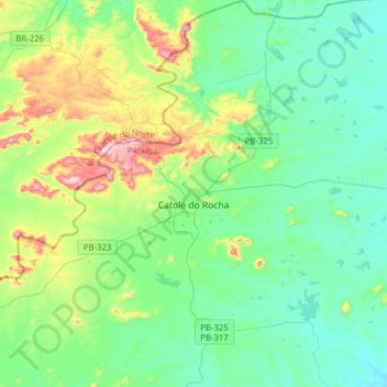
Name: Catolé do Rocha topographic map, elevation, terrain.
Average elevation: 997 ft
Minimum elevation: 551 ft
Maximum elevation: 2,457 ft
Make a donation
Gear up for your next adventure:
As an Amazon Associate, this site earns from qualifying purchases at no extra cost to you.
Other topographic maps
Click on a map to view its topography, its elevation and its terrain.
Serra da Borborema
Brazil > Paraíba > Região Metropolitana de Patos > Cacimbas
Average elevation: 1,880 ft
Make a donation
Gear up for your next adventure:
As an Amazon Associate, this site earns from qualifying purchases at no extra cost to you.
Campina Grande
Brazil > Paraíba > Região Metropolitana de Campina Grande > Campina Grande
Average elevation: 1,634 ft