Geolocate

Machang topographic map

Click on the map to display elevation.

About this map

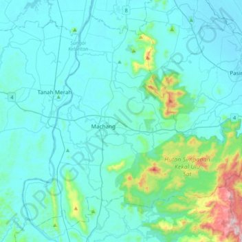
Name: Machang topographic map, elevation, terrain.

Location: Machang, Kelantan, 18500, Malaysia (5.62850 102.10520 5.91363 102.43139)

Average elevation: 305 ft

Minimum elevation: 3 ft

Maximum elevation: 2,648 ft

Other topographic maps

Click on a map to view its topography, its elevation and its terrain.

Gua Musang

Malaysia > Kelantan

Average elevation: 472 ft

Kampung Repek

Malaysia > Kelantan

Average elevation: 16 ft

Kampung Telaga Papan

Malaysia > Kelantan

Average elevation: 20 ft

Mount Chamah

Malaysia > Kelantan

Average elevation: 5,938 ft

Selising

Malaysia > Kelantan

Average elevation: 39 ft

Bukit Abal

Malaysia > Kelantan

Average elevation: 39 ft

Sungai Long

Malaysia > Kelantan > Sungai Long

Average elevation: 1,325 ft

Kampung Pulau Gajah

Malaysia > Kelantan > Kota Bharu

Average elevation: 20 ft

Sungai Jeram

Malaysia > Kelantan

Average elevation: 121 ft

Gunung Yong Belar

Malaysia > Kelantan

Average elevation: 5,620 ft

Pergau Dam

Malaysia > Kelantan

Average elevation: 2,080 ft

Gear up for your next adventure:

🪑Ultralight Camp Chairs - Portable seating for resting after a long day of mapping
🔦Compact Flashlight - Reliable flashlight for emergencies
🛰️Satellite Messengers - Emergency SOS and two-way messaging for off-grid adventures
🔋Solar Power Banks - Keep your GPS and phone charged in remote wilderness areas
🔦Powerful Headlamps - Ultra-bright hands-free lighting for night navigation

As an Amazon Associate, this site earns from qualifying purchases at no extra cost to you.