
Tambach-Dietharz topographic map
Interactive map
Click on the map to display elevation.
About this map
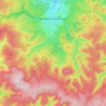
Name: Tambach-Dietharz topographic map, elevation, terrain.
Location: Tambach-Dietharz, Landkreis Gotha, Thüringen, 99897, Duitsland (50.72402 10.53769 50.80924 10.66008)
Average elevation: 2,175 ft
Minimum elevation: 1,378 ft
Maximum elevation: 2,897 ft
Other topographic maps
Click on a map to view its topography, its elevation and its terrain.
Gotha
Duitsland > Thüringen > Landkreis Gotha
Gotha, Landkreis Gotha, Thüringen, Duitsland
Average elevation: 1,050 ft
Friedrichroda
Duitsland > Thüringen > Landkreis Gotha
Friedrichroda, Landkreis Gotha, Thüringen, 99894, Duitsland
Average elevation: 1,624 ft