
Chazous topographic map
Interactive map
Click on the map to display elevation.
About this map
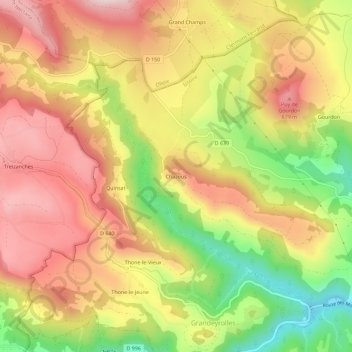
Name: Chazous topographic map, elevation, terrain.
Average elevation: 2,428 ft
Minimum elevation: 1,690 ft
Maximum elevation: 3,002 ft
Other topographic maps
Click on a map to view its topography, its elevation and its terrain.
Puy de Gourdon
Frankreich > Auvergne-Rhone-Alpen > Puy-de-Dôme > Montaigut-le-Blanc
Puy de Gourdon, Montaigut-le-Blanc, Issoire, Puy-de-Dôme, Auvergne-Rhone-Alpen, Metropolitanes Frankreich, 63320, Frankreich
Average elevation: 2,359 ft