Geolocate

Selb topographic map

Click on the map to display elevation.

About this map

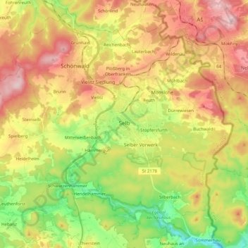
Name: Selb topographic map, elevation, terrain.

Location: Selb, Landkreis Wunsiedel im Fichtelgebirge, Bavaria, 95100, Germany (50.11673 12.01965 50.21995 12.21597)

Average elevation: 1,932 ft

Minimum elevation: 1,476 ft

Maximum elevation: 2,425 ft

Other topographic maps

Click on a map to view its topography, its elevation and its terrain.

Gear up for your next adventure:

🔭Telescopic Hiking Pole - Adjustable pole for hiking stability
🏕️Family Camping Gear - Essentials for group camping trips
🧭Compass with Lanyard - Easy‑carry compass for navigation
🪄Magnetic Compass - Accurate compass for navigation
🧥Men's Rain Shells - Premium waterproof and breathable jackets for mountain weather

As an Amazon Associate, this site earns from qualifying purchases at no extra cost to you.