
Alto topographic map
Click on the map to display elevation.
Alto
The town of Alto was laid out in 1849 and named for the Spanish word meaning "high" on account of the site's elevation on a drainage divide between the Neches and Angelina Rivers.
About this map
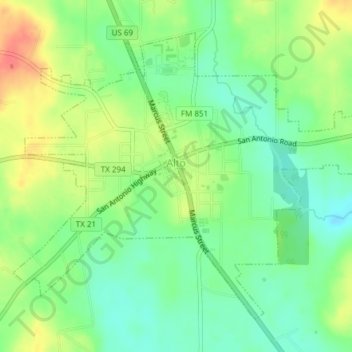
Name: Alto topographic map, elevation, terrain.
Location: Alto, Cherokee County, Texas, United States (31.63611 -95.09026 31.66238 -95.05245)
Average elevation: 427 ft
Minimum elevation: 348 ft
Maximum elevation: 535 ft
Cherokee County trails, hiking, mountain biking, running and outdoor activities
Other topographic maps
Click on a map to view its topography, its elevation and its terrain.
Jacksonville
United States > Texas > Cherokee County > Jacksonville > Jacksonville
Average elevation: 505 ft