Geolocate

Ordes topographic map

Click on the map to display elevation.

About this map

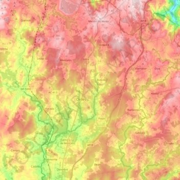
Name: Ordes topographic map, elevation, terrain.

Location: Ordes, A Coruña, Galicia, Spain (43.00064 -8.49482 43.16994 -8.31794)

Average elevation: 1,076 ft

Minimum elevation: 404 ft

Maximum elevation: 1,519 ft

Other topographic maps

Click on a map to view its topography, its elevation and its terrain.

Hospital

Spain > Galicia > Ordes

Average elevation: 1,325 ft

Cruz de Nouche

Spain > Galicia > Ordes > Beán

Average elevation: 1,024 ft

Meitufe do Medio

Spain > Galicia > Ordes > Ordes

Average elevation: 1,257 ft

O Canedo

Spain > Galicia > Ordes

Average elevation: 1,234 ft

Gear up for your next adventure:

🧭Pro Hiking Compasses - High-accuracy liquid-filled compasses for topographic orientation
Camping Coffee Makers - Enjoy premium coffee at the summit or campsite
🔭Stargazing Telescopes - Perfect for camping in low-light pollution areas shown on maps
🪶LED Camping Lantern - Bright lantern for camp lighting
🕶️Glacier Sunglasses - Side shields to protect eyes from high-altitude snow glare

As an Amazon Associate, this site earns from qualifying purchases at no extra cost to you.