
Make a donation
Gear up for your next adventure:
As an Amazon Associate, this site earns from qualifying purchases at no extra cost to you.
Medellín topographic map
Click on the map to display elevation.
Make a donation
Gear up for your next adventure:
As an Amazon Associate, this site earns from qualifying purchases at no extra cost to you.
Medellín
Medellín has 16 comunas (districts), 5 corregimientos (townships), and 271 barrios (neighborhoods). The metropolitan area of Medellín lies within the Aburrá valley at an elevation of 1,500 metres (4,900 feet) above sea level and is bisected by the Medellín River (also called Porce), which flows northward. North of the valley are the towns of Bello, Copacabana, Girardota and Barbosa. To the south of the valley lie Itagüí, Envigado, Sabaneta, La Estrella and Caldas.
Make a donation
Gear up for your next adventure:
As an Amazon Associate, this site earns from qualifying purchases at no extra cost to you.
About this map
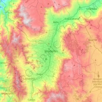
Name: Medellín topographic map, elevation, terrain.
Location: Medellín, Valle de Aburrá, Antioquia, 0500, Colombia (6.08434 -75.73355 6.40434 -75.41355)
Average elevation: 6,883 ft
Minimum elevation: 3,392 ft
Maximum elevation: 10,249 ft
Make a donation
Gear up for your next adventure:
As an Amazon Associate, this site earns from qualifying purchases at no extra cost to you.
Other topographic maps
Click on a map to view its topography, its elevation and its terrain.
Comuna 13 - San Javier
Colombia > Antioquia > Medellín
Comuna 13's geography has played a role in how criminal actors took advantage of the commune as a strategic location, using elevation to better survey the movement of police and rival groups. The elevation additionally played a historical role, as Comuna 13 began as a farming community.
Average elevation: 5,620 ft
Make a donation
Gear up for your next adventure:
As an Amazon Associate, this site earns from qualifying purchases at no extra cost to you.