Geolocate

Taghazout topographic map

Click on the map to display elevation.

About this map
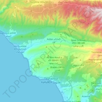
Name: Taghazout topographic map, elevation, terrain.

Location: Taghazout, caïdat de Taghazout, cercle d'Agadir-Atlantique, Agadir Ida-Outanane Prefecture, Souss-Massa, Morocco (30.52493 -9.75527 30.64396 -9.59492)

Average elevation: 886 ft

Minimum elevation: -3 ft

Maximum elevation: 3,415 ft

Other topographic maps

Click on a map to view its topography, its elevation and its terrain.
Gear up for your next adventure:

🔭Compact Binoculars - HD vision for scouting terrain and identifying distant landmarks
🛶Inflatable Kayak - Portable kayak for rivers, lakes, and expeditions
⌚Solar GPS Watches - Advanced multisport watches with built-in topographic maps
🎒Trail Energy Bars - High‑calorie bars for hiking energy
🎁Geography Themed Gifts - Unique gift ideas for map lovers and geography enthusiasts

As an Amazon Associate, this site earns from qualifying purchases at no extra cost to you.