
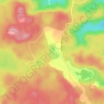
Lake Rototuna topographic map
Interactive map
Click on the map to display elevation.
About this map
Name: Lake Rototuna topographic map, elevation, terrain.
Average elevation: 394 ft
Minimum elevation: 69 ft
Maximum elevation: 581 ft
Other topographic maps
Click on a map to view its topography, its elevation and its terrain.
Lake Humuhumu
Lake Humuhumu, Pouto Road, Pouto, Kaipara District, Northland, New Zealand
Average elevation: 223 ft
Lake Waingata
Lake Waingata, Pouto Road, Pouto, Kaipara District, Northland, New Zealand
Average elevation: 197 ft
Lake Kanono
Lake Kanono, Pouto Road, Pouto, Kaipara District, Northland, New Zealand
Average elevation: 220 ft
Lake Kahuparere
Lake Kahuparere, Pouto Road, Pouto, Kaipara District, Northland, New Zealand
Average elevation: 180 ft
Lake Rotootuauru
Lake Rotootuauru, Pouto Road, Pouto, Kaipara District, Northland, New Zealand
Average elevation: 190 ft
Lake Karaka
Lake Karaka, Pouto Road, Pouto, Kaipara District, Northland, New Zealand
Average elevation: 105 ft