Geolocate

Pook topographic map

Click on the map to display elevation.

About this map

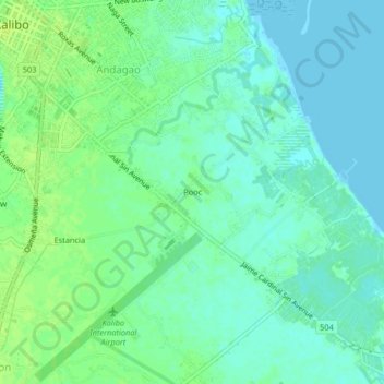
Name: Pook topographic map, elevation, terrain.

Location: Pook, Kalibo, Aklan, Western Visayas, 5600, Philippines (11.67140 122.36330 11.71140 122.40330)

Average elevation: 20 ft

Minimum elevation: -7 ft

Maximum elevation: 43 ft

Other topographic maps

Click on a map to view its topography, its elevation and its terrain.

Pastrana Park

Philippines > Aklan > Kalibo > Mobo

Average elevation: 26 ft

Gear up for your next adventure:

📶Vehicle Signal Boosters - Improve reception in rural areas while driving to trailheads
🔊Portable Camp Speaker - Music and alerts at camp
🧦Merino Wool Socks - Moisture-wicking, blister-preventing socks for long treks
🚁Photography Drones - Capture stunning aerial views of landforms and topography
🔥Fast-Boil Camping Stoves - Efficient cooking systems for quick trail meals

As an Amazon Associate, this site earns from qualifying purchases at no extra cost to you.