
Make a donation
Gear up for your next adventure:
As an Amazon Associate, this site earns from qualifying purchases at no extra cost to you.
Anápolis topographic map
Click on the map to display elevation.
Make a donation
Gear up for your next adventure:
As an Amazon Associate, this site earns from qualifying purchases at no extra cost to you.
Anápolis
Anápolis is located in Center-Western Brazil. It is located in a plateau, called Central Plateau, at an elevation of 1,017 metres (3,337 ft). The area is 918.3 square kilometres (354.6 sq mi), and the limiting municipalities are Abadiânia, Campo Limpo de Goiás, Gameleira de Goiás, Goianápolis, Leopoldo de Bulhões, Nerópolis, Pirenópolis, Silvânia and Terezópolis de Goiás. Anápolis is also the center of the Anápolis Microregion, and belongs to the Goiás Center mesoregion.
Make a donation
Gear up for your next adventure:
As an Amazon Associate, this site earns from qualifying purchases at no extra cost to you.
About this map
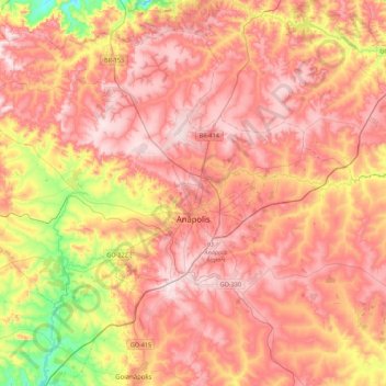
Name: Anápolis topographic map, elevation, terrain.
Average elevation: 3,228 ft
Minimum elevation: 2,369 ft
Maximum elevation: 3,783 ft
Make a donation
Gear up for your next adventure:
As an Amazon Associate, this site earns from qualifying purchases at no extra cost to you.
Other topographic maps
Click on a map to view its topography, its elevation and its terrain.
Make a donation
Gear up for your next adventure:
As an Amazon Associate, this site earns from qualifying purchases at no extra cost to you.
Rosa
Brazil > Goiás > Região Integrada de Desenvolvimento do Distrito Federal e Entorno > Pirenópolis
Average elevation: 2,559 ft
Bom Jesus
Brazil > Goiás > Região Integrada de Desenvolvimento do Distrito Federal e Entorno > Pirenópolis
Average elevation: 2,493 ft
Make a donation
Gear up for your next adventure:
As an Amazon Associate, this site earns from qualifying purchases at no extra cost to you.
Rio Arraial Velho
Brazil > Goiás > Região Integrada de Desenvolvimento do Distrito Federal e Entorno > Água Fria de Goiás
Average elevation: 2,779 ft
Paiol Velho
Brazil > Goiás > Região Integrada de Desenvolvimento do Distrito Federal e Entorno > Pirenópolis
Average elevation: 2,395 ft