
Make a donation
Gear up for your next adventure:
As an Amazon Associate, this site earns from qualifying purchases at no extra cost to you.
South Mountain topographic map
Click on the map to display elevation.
Make a donation
Gear up for your next adventure:
As an Amazon Associate, this site earns from qualifying purchases at no extra cost to you.
South Mountain
Unlike Blue Mountain to its north, South Mountain does not follow a straight geographic line. The mountain ranges in elevation between 500 and 1,300 feet (150 and 400 m) above sea level. The ridge is made of metamorphic rocks and gneiss, which date to the Precambrian era and range from about 570 million to 1,600 million years old.
Make a donation
Gear up for your next adventure:
As an Amazon Associate, this site earns from qualifying purchases at no extra cost to you.
About this map
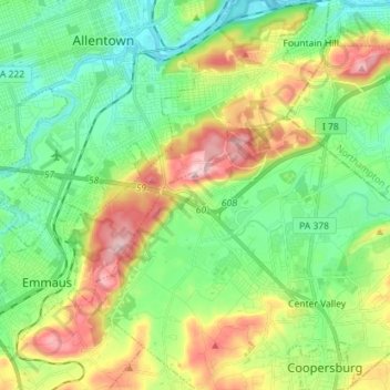
Name: South Mountain topographic map, elevation, terrain.
Average elevation: 502 ft
Minimum elevation: 223 ft
Maximum elevation: 1,037 ft
Lehigh County trails, hiking, mountain biking, running and outdoor activities
Make a donation
Gear up for your next adventure:
As an Amazon Associate, this site earns from qualifying purchases at no extra cost to you.