Geolocate

Policoro topographic map

Click on the map to display elevation.

About this map

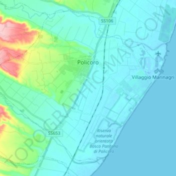
Name: Policoro topographic map, elevation, terrain.

Location: Policoro, Matera, Basilicata, 75025, Italy (40.14771 16.59884 40.24152 16.73775)

Average elevation: 66 ft

Minimum elevation: -10 ft

Maximum elevation: 472 ft

Other topographic maps

Click on a map to view its topography, its elevation and its terrain.

Tempa Parese

Italy > Basilicata > Matera > Stigliano

Average elevation: 1,394 ft

Torricelli

Italy > Basilicata > Matera > Ferrandina

Average elevation: 925 ft

Pianelle

Italy > Basilicata > Matera > Montescaglioso > Pianelle

Average elevation: 512 ft

Gear up for your next adventure:

🌧️Backpack Rain Cover - Keep gear dry in wet weather
🎒Hydration Pack - Hands‑free water reservoir for long hikes
🛠️Backpacking Tool Kit - Essential toolkit for outdoor repairs
👟Men's Trail Runners - Lightweight footwear for fast-paced exploration and light hiking
📖Nature Tracking Books - Learn to track wildlife and terrain

As an Amazon Associate, this site earns from qualifying purchases at no extra cost to you.