
La Chaux-de-Fonds topographic map
Interactive map
Click on the map to display elevation.
About this map
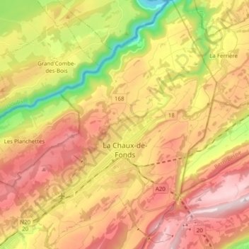
Name: La Chaux-de-Fonds topographic map, elevation, terrain.
Location: La Chaux-de-Fonds, Neuchâtel, Switzerland (47.06165 6.76420 47.16559 6.88880)
Average elevation: 3,409 ft
Minimum elevation: 1,998 ft
Maximum elevation: 4,639 ft
La Chaux-de-Fonds (French pronunciation: [laʃodəfɔ̃]) is a Swiss city in the canton of Neuchâtel. It is located in the Jura mountains at an altitude of 1000 m, a few kilometers south of the French border. After Geneva, Lausanne and Fribourg, it is the fourth largest city located in the Romandie, the French-speaking part of the country, with a population (as of December 2020) of 36,915.
Other topographic maps
Click on a map to view its topography, its elevation and its terrain.
Marmoud
Switzerland > Neuchâtel > La Sagne
Marmoud, La Sagne, Neuchâtel, 2314, Switzerland
Average elevation: 3,825 ft
Noiraigue
Switzerland > Neuchâtel > Val-de-Travers
Noiraigue, Val-de-Travers, Neuchâtel, 2103, Switzerland
Average elevation: 3,219 ft
Lake Neuchâtel
Switzerland > Neuchâtel > District de la Broye
Lake Neuchâtel, District de la Broye, Seeland administrative region, Neuchâtel, Switzerland
Average elevation: 2,159 ft
Val-de-Travers
Val-de-Travers, Neuchâtel, Switzerland
Average elevation: 3,412 ft