
Thank you for supporting this site ❤️
Make a donation
Make a donation
Gear up for your next adventure:
As an Amazon Associate, this site earns from qualifying purchases at no extra cost to you.
Marmoud topographic map
Click on the map to display elevation.
Thank you for supporting this site ❤️
Make a donation
Make a donation
Gear up for your next adventure:
As an Amazon Associate, this site earns from qualifying purchases at no extra cost to you.
About this map
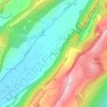
Name: Marmoud topographic map, elevation, terrain.
Location: Marmoud, La Sagne, Neuchâtel, 2314, Switzerland (47.01224 6.78798 47.05224 6.82798)
Average elevation: 3,825 ft
Minimum elevation: 3,274 ft
Maximum elevation: 4,698 ft
Thank you for supporting this site ❤️
Make a donation
Make a donation
Gear up for your next adventure:
As an Amazon Associate, this site earns from qualifying purchases at no extra cost to you.