
Wahlitz topographic map
Interactive map
Click on the map to display elevation.
About this map
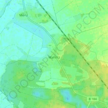
Name: Wahlitz topographic map, elevation, terrain.
Location: Wahlitz, Gommern, Jerichower Land, Sachsen-Anhalt, Deutschland (52.09052 11.74740 52.11897 11.80810)
Average elevation: 164 ft
Minimum elevation: 141 ft
Maximum elevation: 197 ft
Other topographic maps
Click on a map to view its topography, its elevation and its terrain.
Vehlitz
Deutschland > Sachsen-Anhalt > Jerichower Land > Gommern
Vehlitz, Gommern, Jerichower Land, Sachsen-Anhalt, Deutschland
Average elevation: 194 ft
Dannigkow
Deutschland > Sachsen-Anhalt > Jerichower Land > Gommern
Dannigkow, Gommern, Jerichower Land, Sachsen-Anhalt, Deutschland
Average elevation: 194 ft
Ladeburg
Deutschland > Sachsen-Anhalt > Jerichower Land > Gommern
Ladeburg, Gommern, Jerichower Land, Sachsen-Anhalt, Deutschland
Average elevation: 246 ft