
Boreen Point topographic map
Interactive map
Click on the map to display elevation.
About this map
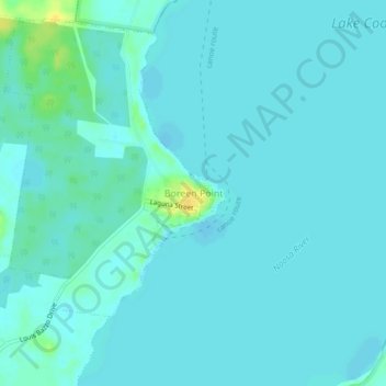
Name: Boreen Point topographic map, elevation, terrain.
Location: Boreen Point, Queensland, Australia (-26.30397 152.97473 -26.26397 153.01473)
Average elevation: 13 ft
Minimum elevation: 0 ft
Maximum elevation: 82 ft
Other topographic maps
Click on a map to view its topography, its elevation and its terrain.
Lake Cootharaba
Australia > Queensland > Boreen Point
Lake Cootharaba, Boreen Point, Noosa Shire, Queensland, Australia
Average elevation: 26 ft
Cooroibah
Australia > Queensland > Boreen Point
Cooroibah, Boreen Point, Queensland, Australia
Average elevation: 20 ft