
Dallah topographic map
Interactive map
Click on the map to display elevation.
About this map
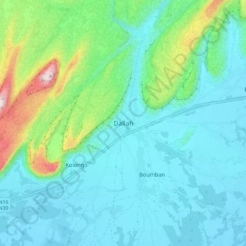
Name: Dallah topographic map, elevation, terrain.
Location: Dallah, Cercle de Douentza, Mopti, Mali (15.06528 -2.68028 15.14528 -2.60028)
Average elevation: 1,306 ft
Minimum elevation: 971 ft
Maximum elevation: 2,690 ft
Other topographic maps
Click on a map to view its topography, its elevation and its terrain.
Douentza
Mali > Mopti > Cercle de Douentza
Douentza, Cercle de Douentza, Mopti, Mali
Average elevation: 1,293 ft