
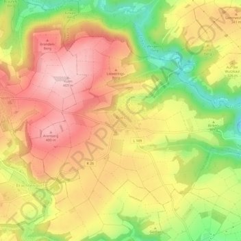
Roes topographic map
Interactive map
Click on the map to display elevation.
About this map
Name: Roes topographic map, elevation, terrain.
Average elevation: 1,027 ft
Minimum elevation: 597 ft
Maximum elevation: 1,348 ft
Other topographic maps
Click on a map to view its topography, its elevation and its terrain.
Beilstein
Duitsland > Rijnland-Palts > Landkreis Cochem-Zell
Beilstein, Cochem, Landkreis Cochem-Zell, Rijnland-Palts, Duitsland
Average elevation: 768 ft
Neef
Duitsland > Rijnland-Palts > Landkreis Cochem-Zell
Neef, Zell (Mosel), Landkreis Cochem-Zell, Rijnland-Palts, Duitsland
Average elevation: 699 ft
Zell (Mosel)
Duitsland > Rijnland-Palts > Landkreis Cochem-Zell
Zell (Mosel), Landkreis Cochem-Zell, Rijnland-Palts, 56856, Duitsland
Average elevation: 942 ft
Lutzerath
Duitsland > Rijnland-Palts > Landkreis Cochem-Zell
Lutzerath, Ulmen, Landkreis Cochem-Zell, Rijnland-Palts, 56826, Duitsland
Average elevation: 1,260 ft
Cochem
Duitsland > Rijnland-Palts > Landkreis Cochem-Zell
Cochem, Landkreis Cochem-Zell, Rijnland-Palts, Duitsland
Average elevation: 938 ft
Bad Bertrich
Duitsland > Rijnland-Palts > Landkreis Cochem-Zell
Bad Bertrich, Ulmen, Landkreis Cochem-Zell, Rijnland-Palts, 56864, Duitsland
Average elevation: 1,079 ft
Brauheck
Duitsland > Rijnland-Palts > Landkreis Cochem-Zell > Cochem
Brauheck, Cochem, Landkreis Cochem-Zell, Rijnland-Palts, Duitsland
Average elevation: 1,135 ft
Gevenich
Duitsland > Rijnland-Palts > Landkreis Cochem-Zell > Gevenich
Gevenich, Ulmen, Landkreis Cochem-Zell, Rijnland-Palts, Duitsland
Average elevation: 1,325 ft
Ediger-Eller
Duitsland > Rijnland-Palts > Landkreis Cochem-Zell
Ediger-Eller, Cochem, Landkreis Cochem-Zell, Rijnland-Palts, Duitsland
Average elevation: 840 ft