Geolocate

青龙乡 topographic map

Interactive map

Click on the map to display elevation.

About this map

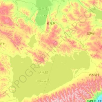
Name: 青龙乡 topographic map, elevation, terrain.

Location: 青龙乡, 班戈县, 那曲市, 西藏自治区, 中国 (30.50326 90.25017 31.35203 90.97463)

Average elevation: 15,915 ft

Minimum elevation: 14,009 ft

Maximum elevation: 19,327 ft

Other topographic maps

Click on a map to view its topography, its elevation and its terrain.

新吉乡

中国 > 西藏自治区 > 班戈县

新吉乡, 班戈县, 那曲市, 西藏自治区, 中国

Average elevation: 16,549 ft

佳琼镇

中国 > 西藏自治区 > 班戈县

佳琼镇, 班戈县, 那曲市, 西藏自治区, 中国

Average elevation: 15,679 ft

德庆镇

中国 > 西藏自治区 > 班戈县

德庆镇, 班戈县, 那曲市, 西藏自治区, 中国

Average elevation: 16,739 ft

北拉镇

中国 > 西藏自治区 > 班戈县

北拉镇, 班戈县, 那曲市, 西藏自治区, 中国

Average elevation: 15,676 ft

班戈错

中国 > 西藏自治区 > 班戈县

班戈错, S301, 班戈县, 那曲市, 西藏自治区, 中国

Average elevation: 14,934 ft