
Portslade by Sea topographic map
Interactive map
Click on the map to display elevation.
About this map
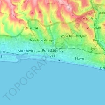
Name: Portslade by Sea topographic map, elevation, terrain.
Average elevation: 115 ft
Minimum elevation: -3 ft
Maximum elevation: 512 ft
Other topographic maps
Click on a map to view its topography, its elevation and its terrain.
Shoreham Harbour (East Arm)
United Kingdom > England > Brighton and Hove > Portslade by Sea
Shoreham Harbour (East Arm), Portslade Village, Portslade by Sea, Brighton and Hove, England, United Kingdom
Average elevation: 33 ft
Brighton
United Kingdom > England > Brighton and Hove
Brighton, Brighton and Hove, England, United Kingdom
Average elevation: 210 ft