
County Down topographic map
Interactive map
Click on the map to display elevation.
About this map
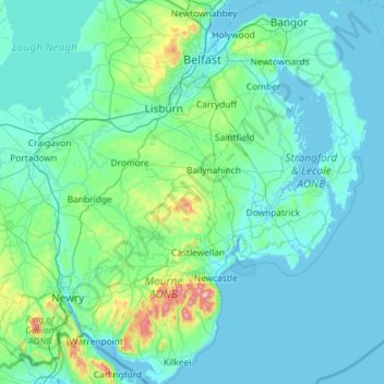
Name: County Down topographic map, elevation, terrain.
Location: County Down, Northern Ireland, United Kingdom (54.02289 -6.40037 54.69924 -5.42682)
Average elevation: 213 ft
Minimum elevation: -10 ft
Maximum elevation: 2,753 ft
Other topographic maps
Click on a map to view its topography, its elevation and its terrain.
Killyberry Boyd
United Kingdom > Northern Ireland
Killyberry Boyd, Northern Ireland, United Kingdom
Average elevation: 115 ft
Hilltown
United Kingdom > Northern Ireland > County Down
Hilltown, County Down, Northern Ireland, BT34 5UH, United Kingdom
Average elevation: 446 ft
Newcastle Road
United Kingdom > Northern Ireland
Newcastle Road, Northern Ireland, United Kingdom
Average elevation: 26 ft
Newtownards
United Kingdom > Northern Ireland > County Down
Newtownards, County Down, Northern Ireland, BT23 4FA, United Kingdom
Average elevation: 164 ft
Whiterock
United Kingdom > Northern Ireland > County Down
Whiterock, County Down, Northern Ireland, BT23 6QH, United Kingdom
Average elevation: 36 ft
Binian Lough
United Kingdom > Northern Ireland > County Down
Binian Lough, County Down, Northern Ireland, United Kingdom
Average elevation: 1,348 ft
Clough
United Kingdom > Northern Ireland > County Down
Clough, County Down, Ulster, Northern Ireland, BT30 8RB, United Kingdom
Average elevation: 105 ft
Belfast
United Kingdom > Northern Ireland > County Antrim
Belfast, County Antrim, Northern Ireland, United Kingdom
Average elevation: 302 ft
Giant's Causeway
United Kingdom > Northern Ireland > County Antrim
Giant's Causeway, County Antrim, Ulster, Northern Ireland, United Kingdom
Average elevation: 85 ft
Cave Hill
United Kingdom > Northern Ireland > County Antrim > Belfast
Cave Hill, Greencastle, Belfast, County Antrim, Northern Ireland, BT15 5GL, United Kingdom
Average elevation: 564 ft
Whitecross
United Kingdom > Northern Ireland
Whitecross, Newry, Mourne and Down District Council, Northern Ireland, BT60 2UF, United Kingdom
Average elevation: 417 ft
West Division
United Kingdom > Northern Ireland
West Division, Northern Ireland, United Kingdom
Average elevation: 420 ft
Crossmaglen
United Kingdom > Northern Ireland
Crossmaglen, Newry, Mourne and Down District Council, Northern Ireland, United Kingdom
Average elevation: 404 ft
Cappagh
United Kingdom > Northern Ireland
Cappagh, Northern Ireland, United Kingdom
Average elevation: 768 ft
Drumragh (Caldwell)
United Kingdom > Northern Ireland > County Tyrone
Drumragh (Caldwell), County Tyrone, Ulster, Northern Ireland, United Kingdom
Average elevation: 285 ft
Dungannon
United Kingdom > Northern Ireland > County Tyrone
Dungannon, County Tyrone, Northern Ireland, BT70 1BD, United Kingdom
Average elevation: 249 ft
Carryduff
United Kingdom > Northern Ireland > County Down
Carryduff, County Down, Ulster, Northern Ireland, BT8 8DN, United Kingdom
Average elevation: 361 ft
Portadown
United Kingdom > Northern Ireland > County Armagh
Portadown, County Armagh, Ulster, Northern Ireland, BT62 1BF, United Kingdom
Average elevation: 92 ft
Loughgall
United Kingdom > Northern Ireland > County Armagh
Loughgall, County Armagh, Ulster, Northern Ireland, BT61 8HY, United Kingdom
Average elevation: 105 ft
Belcoo
United Kingdom > Northern Ireland > County Fermanagh
Belcoo, County Fermanagh, Ulster, Northern Ireland, BT93 5FB, United Kingdom
Average elevation: 282 ft
Ahoghill
United Kingdom > Northern Ireland > County Antrim
Ahoghill, County Antrim, Ulster, Northern Ireland, BT42 1JZ, United Kingdom
Average elevation: 276 ft
Moher
United Kingdom > Northern Ireland > County Fermanagh
Moher, Lea, County Fermanagh, Ulster, Northern Ireland, BT92 4FJ, United Kingdom
Average elevation: 213 ft
Aughnahoory
United Kingdom > Northern Ireland > County Down > Kilkeel
Aughnahoory, Kilkeel, County Down, Ulster, Northern Ireland, United Kingdom
Average elevation: 197 ft
County Armagh
United Kingdom > Northern Ireland
County Armagh, Ulster, Northern Ireland, United Kingdom
Average elevation: 322 ft
County Londonderry
United Kingdom > Northern Ireland
County Londonderry, Ulster, Northern Ireland, United Kingdom
Average elevation: 420 ft
Mourne Mountains Middle
United Kingdom > Northern Ireland
Mourne Mountains Middle, Ulster, Northern Ireland, United Kingdom
Average elevation: 1,142 ft
Tempo
United Kingdom > Northern Ireland > County Fermanagh
Tempo, County Fermanagh, Ulster, Northern Ireland, BT94 3LU, United Kingdom
Average elevation: 417 ft
Ballyfatten
United Kingdom > Northern Ireland
Ballyfatten, Ulster, Northern Ireland, BT82 9PY, United Kingdom
Average elevation: 112 ft
Coleraine
United Kingdom > Northern Ireland > County Londonderry
Coleraine, County Londonderry, Ulster, Northern Ireland, BT52 1EP, United Kingdom
Average elevation: 131 ft
McLean's Hill
United Kingdom > Northern Ireland > County Down > Bryansford
McLean's Hill, Bryansford, County Down, Ulster, Northern Ireland, BT31 9HH, United Kingdom
Average elevation: 305 ft
Carr
United Kingdom > Northern Ireland
Carr, Ulster, Northern Ireland, United Kingdom
Average elevation: 197 ft
Horse Island
United Kingdom > Northern Ireland > County Fermanagh
Horse Island, County Fermanagh, Ulster, Northern Ireland, United Kingdom
Average elevation: 151 ft
Armagh
United Kingdom > Northern Ireland > County Armagh > Armagh
Armagh, County Armagh, Ulster, Northern Ireland, United Kingdom
Average elevation: 328 ft
Newry
United Kingdom > Northern Ireland > County Down > Newry
Newry, County Down, Northern Ireland, BT34 1DG, United Kingdom
Average elevation: 423 ft
Limavady
United Kingdom > Northern Ireland > County Londonderry
Limavady, County Londonderry, Ulster, Northern Ireland, BT49 0EP, United Kingdom
Average elevation: 121 ft
Upper Ballysillan
United Kingdom > Northern Ireland > County Antrim
Upper Ballysillan, County Antrim, Northern Ireland, United Kingdom
Average elevation: 833 ft
Glynn
United Kingdom > Northern Ireland > County Antrim > Glynn
Glynn, County Antrim, Northern Ireland, BT40 3HF, United Kingdom
Average elevation: 207 ft
Armagh
United Kingdom > Northern Ireland > Armagh
Armagh, County Armagh, Northern Ireland, BT61 7DJ, United Kingdom
Average elevation: 279 ft
County Antrim
United Kingdom > Northern Ireland
County Antrim, Northern Ireland, United Kingdom
Average elevation: 230 ft
Groomsport
United Kingdom > Northern Ireland > County Down > Groomsport
Groomsport, County Down, Northern Ireland, BT19 6JR, United Kingdom
Average elevation: 33 ft
Newry
United Kingdom > Northern Ireland > County Down > Newry
Newry, County Down, Northern Ireland, United Kingdom
Average elevation: 240 ft
Lough Aghery
United Kingdom > Northern Ireland
Lough Aghery, County Down, Northern Ireland, United Kingdom
Average elevation: 423 ft
Larne
United Kingdom > Northern Ireland > County Antrim > Larne
Larne, County Antrim, Northern Ireland, BT40 1HU, United Kingdom
Average elevation: 177 ft
Dromore
United Kingdom > Northern Ireland > County Down
Dromore, County Down, Northern Ireland, BT25 1BL, United Kingdom
Average elevation: 348 ft
Banbridge
United Kingdom > Northern Ireland > County Down
Banbridge, County Down, Ulster, Northern Ireland, BT32 3AD, United Kingdom
Average elevation: 295 ft
Heron Island
United Kingdom > Northern Ireland > County Fermanagh
Heron Island, County Fermanagh, Ulster, Northern Ireland, United Kingdom
Average elevation: 154 ft
Belfast
United Kingdom > Northern Ireland > County Antrim
Belfast, County Antrim, Ulster, Northern Ireland, BT1 5GS, United Kingdom
Average elevation: 285 ft
Annaclone
United Kingdom > Northern Ireland > Katesbridge
Annaclone, Katesbridge, County Down, Northern Ireland, United Kingdom
Average elevation: 351 ft
White Island
United Kingdom > Northern Ireland
White Island, County Fermanagh, Northern Ireland, United Kingdom
Average elevation: 157 ft
Lisburn
United Kingdom > Northern Ireland > County Antrim
Lisburn, County Antrim, Northern Ireland, BT28 1BJ, United Kingdom
Average elevation: 302 ft