Geolocate

Belfast topographic map

Click on the map to display elevation.

About this map

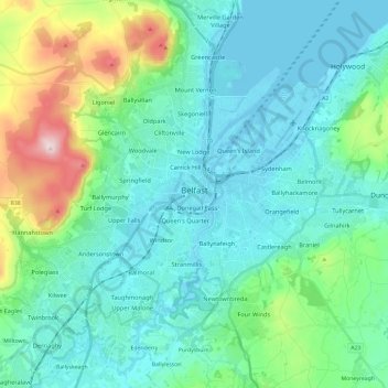
Name: Belfast topographic map, elevation, terrain.

Location: Belfast, County Antrim, Northern Ireland, United Kingdom (54.53061 -6.04548 54.65942 -5.80769)

Average elevation: 302 ft

Minimum elevation: -7 ft

Maximum elevation: 1,562 ft

Other topographic maps

Click on a map to view its topography, its elevation and its terrain.

Glynn

United Kingdom > Northern Ireland > County Antrim > Glynn

Average elevation: 207 ft

Ahoghill

United Kingdom > Northern Ireland > County Antrim

Average elevation: 276 ft

Gear up for your next adventure:

🔭Compact Binoculars - HD vision for scouting terrain and identifying distant landmarks
🔥Camping Stove - Portable stove for camping and backcountry cooking
🌲Outdoor Survival Books - Best books on survival skills
🧤Hiking Gloves - Protective gloves for rugged trails
🚁Photography Drones - Capture stunning aerial views of landforms and topography

As an Amazon Associate, this site earns from qualifying purchases at no extra cost to you.