
Wadi Namar topographic map
Interactive map
Click on the map to display elevation.
About this map
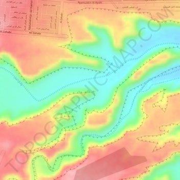
Name: Wadi Namar topographic map, elevation, terrain.
Location: Wadi Namar, Riyadh, Riyadh Region, 14925, Saudi Arabia (24.52833 46.57333 24.54833 46.59333)
Average elevation: 2,323 ft
Minimum elevation: 2,073 ft
Maximum elevation: 2,520 ft
Other topographic maps
Click on a map to view its topography, its elevation and its terrain.
حديقة جبل أبو مخروق
حديقة جبل أبو مخروق, Ad Dubbat District, Riyadh, Riyadh Region, Saudi Arabia
Average elevation: 1,978 ft
Zahrat al Badiah District
Zahrat al Badiah District, Riyadh, Riyadh Region, 12783-8458, Saudi Arabia
Average elevation: 2,133 ft