
Make a donation
Gear up for your next adventure:
As an Amazon Associate, this site earns from qualifying purchases at no extra cost to you.
Wiener Neustadt topographic map
Click on the map to display elevation.
Make a donation
Gear up for your next adventure:
As an Amazon Associate, this site earns from qualifying purchases at no extra cost to you.
About this map
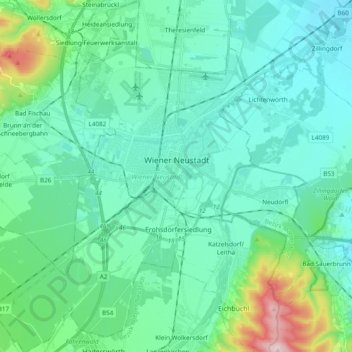
Name: Wiener Neustadt topographic map, elevation, terrain.
Location: Wiener Neustadt, Lower Austria, Austria (47.74268 16.14651 47.87157 16.28590)
Average elevation: 981 ft
Minimum elevation: 761 ft
Maximum elevation: 2,037 ft
Make a donation
Gear up for your next adventure:
As an Amazon Associate, this site earns from qualifying purchases at no extra cost to you.
Other topographic maps
Click on a map to view its topography, its elevation and its terrain.
Suttenbrunn
Austria > Lower Austria > Bezirk Hollabrunn > Gemeinde Hollabrunn
Average elevation: 846 ft
Joachimstal
Austria > Lower Austria > Bezirk Gmünd > Gemeinde Sankt Martin
Average elevation: 2,762 ft
Klosterwappen
Austria > Lower Austria > Bezirk Neunkirchen > Reichenau an der Rax
Average elevation: 5,627 ft
Make a donation
Gear up for your next adventure:
As an Amazon Associate, this site earns from qualifying purchases at no extra cost to you.
Kirchberg an der Pielach
Austria > Lower Austria > Bezirk St. Pölten > Gemeinde Kirchberg an der Pielach > Kirchberg an der Pielach
Average elevation: 1,575 ft
Make a donation
Gear up for your next adventure:
As an Amazon Associate, this site earns from qualifying purchases at no extra cost to you.
Klein-Wien
Austria > Lower Austria > Bezirk Krems > Gemeinde Furth bei Göttweig
Average elevation: 1,010 ft
Sois
Austria > Lower Austria > Bezirk St. Pölten > Gemeinde Kirchberg an der Pielach
Average elevation: 1,621 ft
Plackles
Austria > Lower Austria > Bezirk Wiener Neustadt > Gemeinde Hohe Wand
Average elevation: 2,844 ft
Make a donation
Gear up for your next adventure:
As an Amazon Associate, this site earns from qualifying purchases at no extra cost to you.