
Wanfried topographic map
Interactive map
Click on the map to display elevation.
About this map
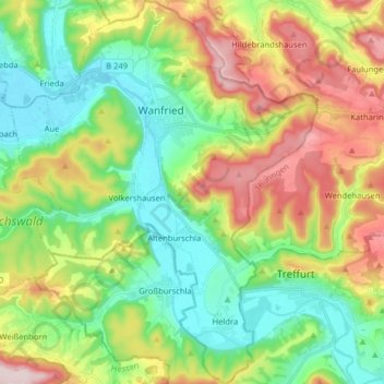
Name: Wanfried topographic map, elevation, terrain.
Location: Wanfried, Werra-Meißner-Kreis, Hessen, 37281, Duitsland (51.11217 10.10573 51.21242 10.23641)
Average elevation: 935 ft
Minimum elevation: 525 ft
Maximum elevation: 1,644 ft
Other topographic maps
Click on a map to view its topography, its elevation and its terrain.
Sontra
Duitsland > Hessen > Werra-Meißner-Kreis
Sontra, Werra-Meißner-Kreis, Hessen, 36205, Duitsland
Average elevation: 1,106 ft
Giesenberg
Duitsland > Hessen > Werra-Meißner-Kreis > Gutsbezirk Kaufunger Wald
Giesenberg, Gutsbezirk Kaufunger Wald, Werra-Meißner-Kreis, Hessen, Duitsland
Average elevation: 1,552 ft
Kalenberg
Duitsland > Hessen > Werra-Meißner-Kreis > Bad Sooden-Allendorf
Kalenberg, Bad Sooden-Allendorf, Werra-Meißner-Kreis, Hessen, 37214, Duitsland
Average elevation: 640 ft