
Mance topographic map
Interactive map
Click on the map to display elevation.
About this map
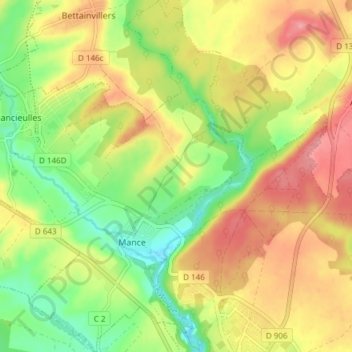
Name: Mance topographic map, elevation, terrain.
Average elevation: 860 ft
Minimum elevation: 689 ft
Maximum elevation: 1,030 ft
Other topographic maps
Click on a map to view its topography, its elevation and its terrain.
Briey
France > Grand Est > Meurthe-et-Moselle > Val de Briey
Briey, Val de Briey, Val-de-Briey, Meurthe-et-Moselle, Grand Est, France métropolitaine, 54150, France
Average elevation: 860 ft