
Belén de los Andaquíes topographic map
Interactive map
Click on the map to display elevation.
About this map
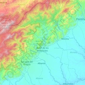
Name: Belén de los Andaquíes topographic map, elevation, terrain.
Location: Belén de los Andaquíes, Caquetá, Colombia (1.18787 -76.10211 1.73949 -75.71757)
Average elevation: 2,615 ft
Minimum elevation: 696 ft
Maximum elevation: 9,449 ft
Other topographic maps
Click on a map to view its topography, its elevation and its terrain.
Chiribiquete (Macizo Central)
Chiribiquete (Macizo Central), Solano, Caquetá, Colombia
Average elevation: 951 ft
burnt forest?
burnt forest?, Solano, Caquetá, Colombia
Average elevation: 617 ft
Puerto Gaitan
Colombia > Caquetá > Puerto Gaitan
Puerto Gaitan, La Montañita, Caquetá, Colombia
Average elevation: 817 ft
La Virgina
Colombia > Caquetá > La Virgina
La Virgina, Morelia, Caquetá, Colombia
Average elevation: 784 ft