
Bois du Parc topographic map
Interactive map
Click on the map to display elevation.
About this map
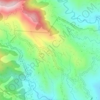
Name: Bois du Parc topographic map, elevation, terrain.
Average elevation: 965 ft
Minimum elevation: 525 ft
Maximum elevation: 1,716 ft
Other topographic maps
Click on a map to view its topography, its elevation and its terrain.
Rabuchon
France > Martinique > Saint-Joseph
Rabuchon, Saint-Joseph, Fort-de-France, Martinique, 97212, France
Average elevation: 932 ft
Au Coeur de Bouliki
France > Martinique > Saint-Joseph
Au Coeur de Bouliki, Saint-Joseph, Fort-de-France, Martinique, 97212, France
Average elevation: 1,391 ft