
Ribes de Freser topographic map
Interactive map
Click on the map to display elevation.
About this map
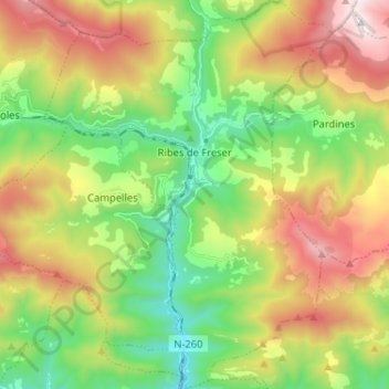
Name: Ribes de Freser topographic map, elevation, terrain.
Location: Ribes de Freser, Ripollès, Gerona, Catalonië, Spanje (42.24749 2.11779 42.34283 2.21352)
Average elevation: 4,419 ft
Minimum elevation: 2,549 ft
Maximum elevation: 7,218 ft
Ribes de Freser is een gemeente in de Spaanse provincie Girona in de regio Catalonië met een oppervlakte van 42 km². In 2007 telde Ribes de Freser 2001 inwoners. Ribes is het onderste eindpunt van de tandradspoorweg van Núria, die toeristen naar het bedevaarts- en skioord Vall de Núria op bijna 2000 meter hoogte in de Pyreneeën brengt.
Other topographic maps
Click on a map to view its topography, its elevation and its terrain.
Collada de Toses
Spanje > Catalonië > Ripollès > Toses
Collada de Toses, Toses, Ripollès, Gerona, Catalonië, 17536, Spanje
Average elevation: 5,830 ft
Puigmal d'Err
Spanje > Catalonië > Ripollès > Queralbs
Puigmal d'Err, Queralbs, Ripollès, Gerona, Catalonië, Spanje
Average elevation: 8,435 ft