Geolocate

Cagliari topographic map

Click on the map to display elevation.

About this map

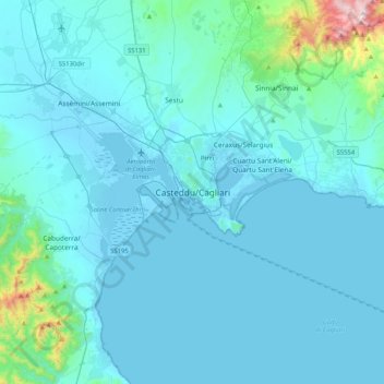
Name: Cagliari topographic map, elevation, terrain.

Location: Cagliari, Sardinia, 09124, Italy (39.05695 8.95285 39.37695 9.27285)

Average elevation: 249 ft

Minimum elevation: -10 ft

Maximum elevation: 3,451 ft

Gear up for your next adventure:

Solar GPS Watches - Advanced multisport watches with built-in topographic maps
🎒Outdoor Daypacks - Lightweight backpacks designed for carrying maps and essential gear
🚗GPS Dash Cams - Record your scenic drives through mountain passes and canyons
🧦Hiking Socks - Comfortable socks to prevent blisters on long hikes
🧴Hand Sanitizer - Keep hands clean while hiking

As an Amazon Associate, this site earns from qualifying purchases at no extra cost to you.