
Oberstdorf topographic map
Click on the map to display elevation.
About this map
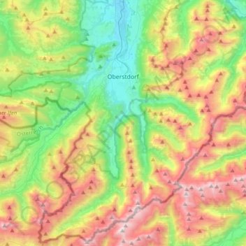
Name: Oberstdorf topographic map, elevation, terrain.
Location: Oberstdorf, Landkreis Oberallgäu, Bavaria, 87561, Germany (47.27011 10.08294 47.47158 10.38930)
Average elevation: 4,888 ft
Minimum elevation: 2,464 ft
Maximum elevation: 8,606 ft
Other topographic maps
Click on a map to view its topography, its elevation and its terrain.
Immenstadt im Allgäu
Germany > Bavaria > Landkreis Oberallgäu > Immenstadt im Allgäu
Average elevation: 2,986 ft
Holdenried
Germany > Bavaria > Landkreis Oberallgäu > Wiggensbach > Wiggensbach
Average elevation: 2,966 ft