
Paint Lick topographic map
Interactive map
Click on the map to display elevation.
About this map
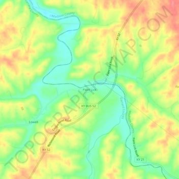
Name: Paint Lick topographic map, elevation, terrain.
Location: Paint Lick, Garrard County, Kentucky, 40461, United States (37.59675 -84.42938 37.63675 -84.38938)
Average elevation: 892 ft
Minimum elevation: 774 ft
Maximum elevation: 1,014 ft
Other topographic maps
Click on a map to view its topography, its elevation and its terrain.
Bryantsville
United States > Kentucky > Garrard County
Bryantsville, Garrard County, Kentucky, 40410, United States
Average elevation: 922 ft
Lancaster
United States > Kentucky > Garrard County
Lancaster, Garrard County, Kentucky, United States
Average elevation: 971 ft