
Cabana de Bergantiños topographic map
Interactive map
Click on the map to display elevation.
About this map
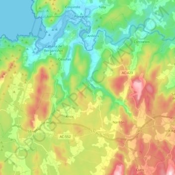
Name: Cabana de Bergantiños topographic map, elevation, terrain.
Location: Cabana de Bergantiños, Bergantiños, A Coruña, Galicia, Spain (43.13490 -8.99281 43.24471 -8.81468)
Average elevation: 554 ft
Minimum elevation: -7 ft
Maximum elevation: 1,532 ft
Other topographic maps
Click on a map to view its topography, its elevation and its terrain.
Carballo
Spain > Galicia > Bergantiños
Carballo, Bergantiños, A Coruña, Galicia, 15102, Spain
Average elevation: 472 ft