
Camp militaire de Chambaran topographic map
Interactive map
Click on the map to display elevation.
About this map
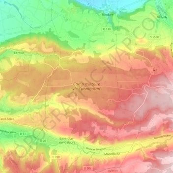
Name: Camp militaire de Chambaran topographic map, elevation, terrain.
Average elevation: 1,490 ft
Minimum elevation: 965 ft
Maximum elevation: 1,906 ft
Other topographic maps
Click on a map to view its topography, its elevation and its terrain.
Saint-Clair-sur-Galaure
France > Auvergne-Rhône-Alpes > Isère > Saint-Clair-sur-Galaure
Saint-Clair-sur-Galaure, Vienne, Isère, Auvergne-Rhône-Alpes, France métropolitaine, 38940, France
Average elevation: 1,562 ft