
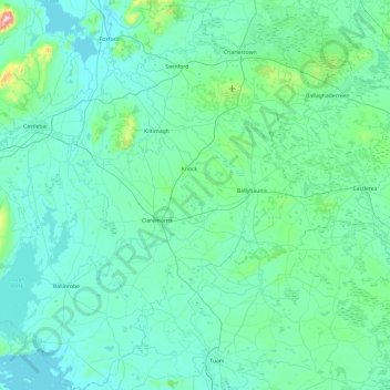
Claremorris-Swinford Municipal District topographic map
Interactive map
Click on the map to display elevation.
About this map
Name: Claremorris-Swinford Municipal District topographic map, elevation, terrain.
Average elevation: 226 ft
Minimum elevation: 10 ft
Maximum elevation: 2,585 ft
Other topographic maps
Click on a map to view its topography, its elevation and its terrain.
Clare Island
Clare Island, Westport-Belmullet Municipal District, County Mayo, Connacht, Ireland
Average elevation: 95 ft
Saleen
Saleen, Hollymount Electoral Division, Claremorris-Swinford Municipal District, County Mayo, Connacht, Ireland
Average elevation: 112 ft
Castlebar
Castlebar, Castlebar Municipal District, County Mayo, Connacht, Ireland
Average elevation: 144 ft
Craggy
Craggy, Clare Island ED, Westport-Belmullet Municipal District, County Mayo, Connacht, Ireland
Average elevation: 135 ft
Ballina Municipal District
Ballina Municipal District, County Mayo, Connacht, Ireland
Average elevation: 243 ft
Blowhole
Blowhole, Ballycastle ED, Ballina Municipal District, County Mayo, Connacht, Ireland
Average elevation: 141 ft
Castlebar Municipal District
Castlebar Municipal District, County Mayo, Connacht, Ireland
Average elevation: 279 ft
Achill Island
Achill Island, County Mayo, Connacht, F28 X018, Ireland
Average elevation: 138 ft
Westport
Ireland > County Mayo > Westport
Westport, Westport-Belmullet Municipal District, County Mayo, Connacht, F28 RD39, Ireland
Average elevation: 131 ft