
La Combe topographic map
Interactive map
Click on the map to display elevation.
About this map
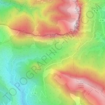
Name: La Combe topographic map, elevation, terrain.
Average elevation: 3,396 ft
Minimum elevation: 1,827 ft
Maximum elevation: 5,128 ft
Other topographic maps
Click on a map to view its topography, its elevation and its terrain.
Fontaine de la Sourde
France > Auvergne-Rhône-Alpes > Drôme > Bézaudun-sur-Bîne > La Combe
Fontaine de la Sourde, D 156, La Combe, Bézaudun-sur-Bîne, Nyons, Drôme, Auvergne-Rhône-Alpes, France métropolitaine, 26460, France
Average elevation: 3,596 ft